Coastal Community Resilience Immersive Training Program
Understanding and addressing the numerous threats facing coastal communities due to climate change and existing factors.
About the Program:
The C-CRIT program is a new partnership between the Coastal Resilience and Sustainability Initiative (CRSI) and Conservation Corps North Carolina, with supporting funding from NC State’s Office of University Interdisciplinary Programs (OUIP) and the Kenan Institute for Engineering, Technology and Science (KIETS). This program will train six AmeriCorps members annually to serve as Assessment Coordinators who will create asset maps and vulnerability assessments of those assets with and for coastal communities who may not have the human or financial capital to do so themselves. This immersive 10-week program is designed to equip students with essential technical skills, including geospatial analysis and GIS software utilization, alongside fostering a deep conceptual grasp of crucial topics like vulnerability, risk, and adaptive capacity. Throughout the program, students will actively engage with partner communities in coastal North Carolina to conduct comprehensive risk and vulnerability assessments.This program will include community engagement to help identify additional assets, like culturally important spaces, as well as localize some of the climate impacts that are already being realized but not captured in downscaled climate predictions, such as areas of recurrent flooding. Ultimately, the students will provide these under-resourced yet climate vulnerable coastal communities with key documents needed to be able to identify and prioritize coastal resilience and sustainability projects, which will help communities secure government funding for those projects.
In future years, training content associated with the program will be transformed into 1-credit online and continuing education courses offered through NC State University.
People and Partners:
The C-CRIT program is being led by Dr. Rebecca Ward, C-CRIT Program Director and CRSI postdoctoral research scholar, and Dr. Georgina Sanchez, C-CRIT Data Analytics Program Mentor and research scholar with the Center for Geospatial Analytics. The C-CRIT leadership team also includes Dr. Erin Seekamp, Director of the Coastal Resilience and Sustainability Initiative, and Amanda Mueller, Director KIETS Climate Leaders Program. Experts within and outside of NC State University are contributing to the program’s training and development.
In the inaugural year of the program, we are excited to be partnering with Jones County, North Carolina. Situated about two hours east of NC State University, Jones County boasts abundant natural and economic resources, including the Trent River, Hofmann Forest, Croatan National Forest, and fertile agricultural lands. Home to the communities of Trenton, Pollocksville, and Maysville, Jones County is only 30 miles from the beach. Despite not bordering the coast directly, Jones County experiences many of the challenges faced by county counties, including more intense rainfall and flooding.

The inaugural group of NC State students serving as Americorps members will start in May 2024 and they will spend 10 weeks in these paid positions, providing them with valuable experiences and communities with critical documents. Congratulations to this year’s cohort of AmeriCorps Assessment Coordinators:
- Lexy Boudreau (environmental engineering major; science technology and society major),
- Sheridan Ely (engineering and Spanish double-major)
- Emma Hester (environmental engineering major),
- Roselyn Hopp (industrial engineering major; environmental science minor),
- Mckinley Richardson (biological and agricultural engineering technology major)
- Jack Voight (environmental engineering major; film studies minor)

2024 C-CRIT Program Deliverables
The 2024 cohort of the Coastal Community Resilience Immersive Training (C-CRIT) Program has successfully completed a comprehensive risk and vulnerability assessment for Jones County, North Carolina, with a focus on flooding, a major hazard for the area.
During the ten-week program, the C-CRIT team collaborated closely with Jones County leaders and community members to map critical assets, including schools, emergency services, and productive lands. Utilizing geospatial analysis and extensive community engagement, the team identified areas of flood exposure and developed a composite vulnerability score for each mapped asset.
A key takeaway from the assessment is that Jones County is already taking proactive measures to enhance its resilience, such as relocating buildings from flood-prone areas and upgrading infrastructure. The findings from C-CRIT’s assessment provide valuable insights that can help the county prioritize future investments in infrastructure and community resilience initiatives related to flooding.
Explore the deliverables from the 2024 C-CRIT Program:
- Online StoryMap, Jones County Resilience, which synthesizes the risk and vulnerability assessment
- Detailed Risk and Vulnerability Assessment Report and Appendices for Jones County, NC

On July 19, 2024, the 2024 C-CRIT cohort held a poster symposium to celebrate their collective achievements. Each member showcased a poster highlighting a topic they were especially passionate about and their contributions to the report. Explore the posters below.
2024 C-CRIT symposium Posters
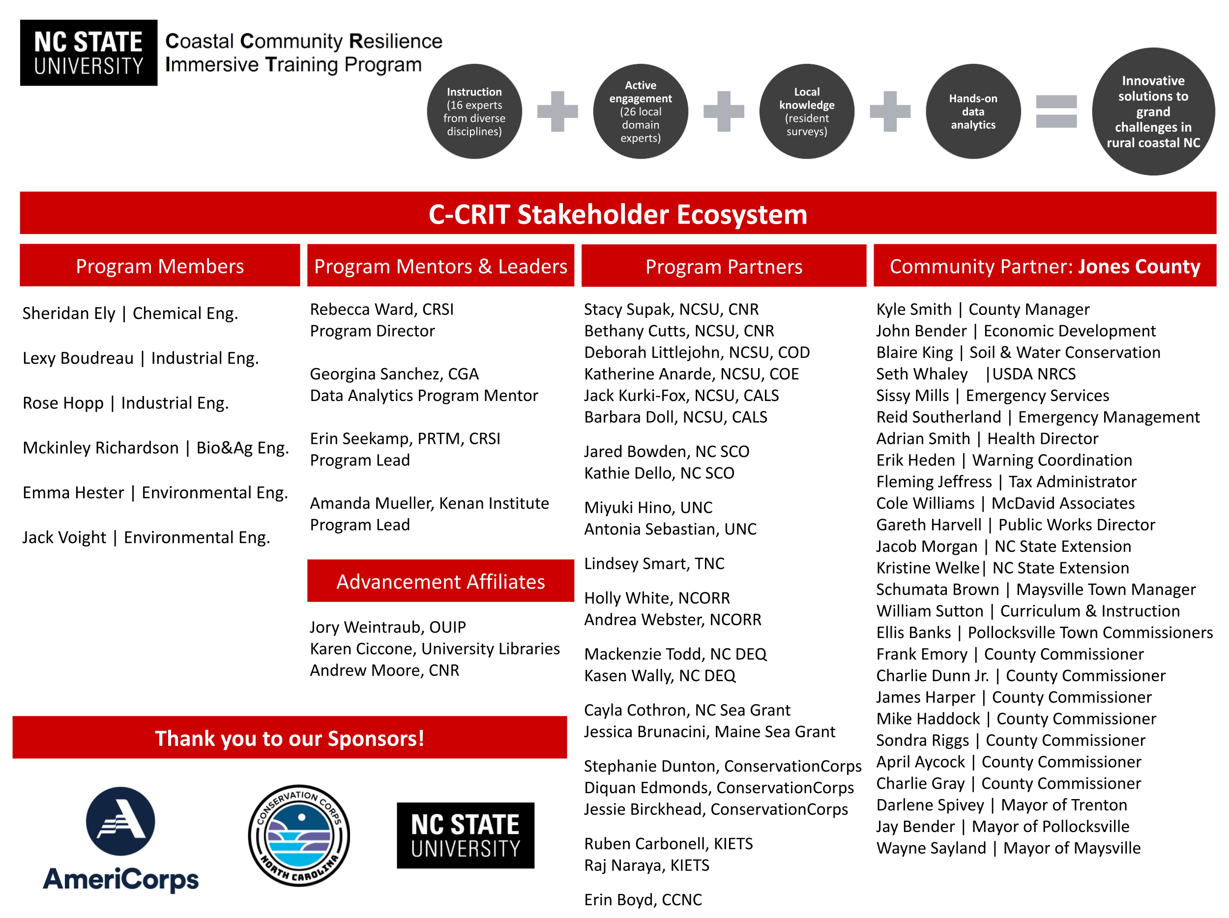
C-CRIT Stakeholder Ecosystem
Read more
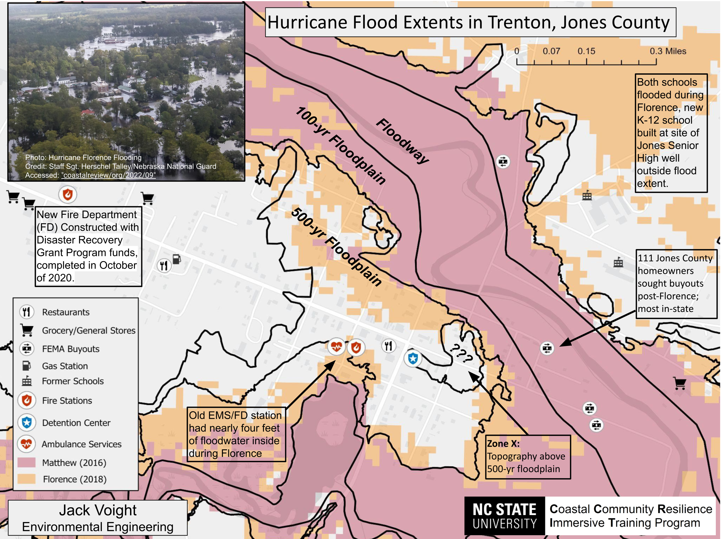
Hurricane Flood Extents in Trenton, Jones County
Read more

Communityy Engagement: Strategies and Takeaways
Read more

Jones County Productive Land Utilization and Trends
Read more
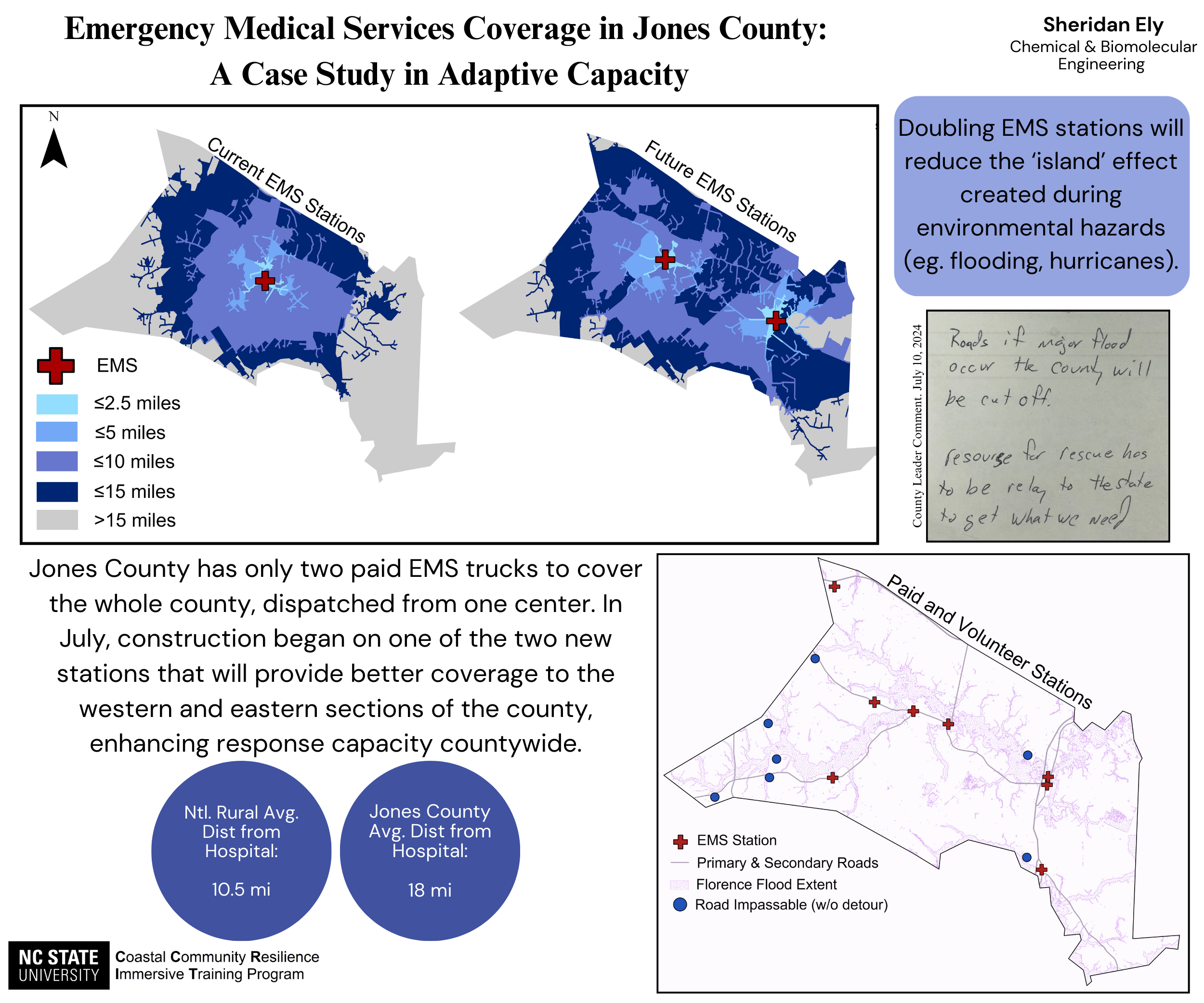
Emergency Medical Services Coverage in Jones County: A Case Study in Adaptive Capacity
Read more
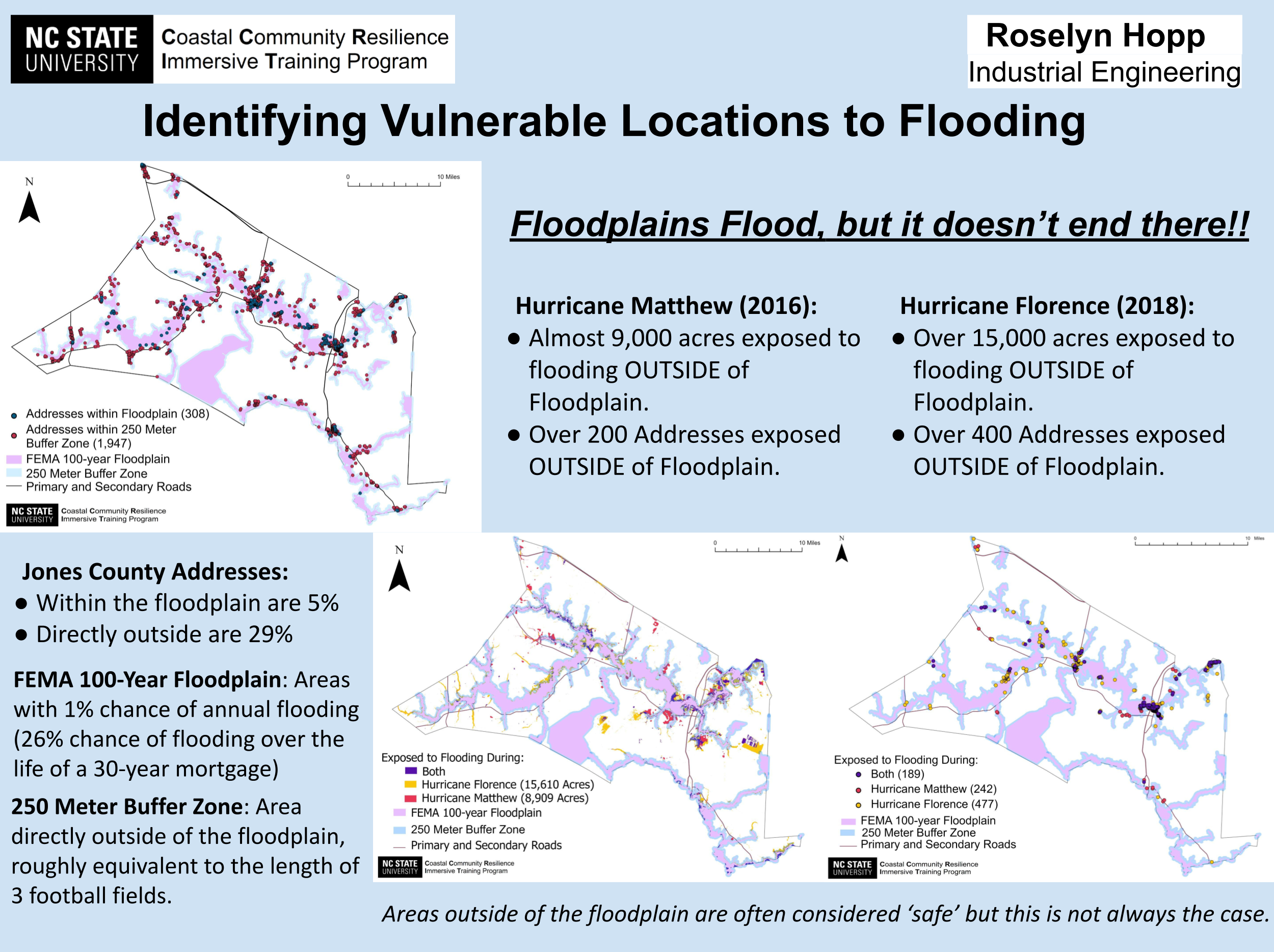
Identifying Vulnderable Locations to Flooding
Read more
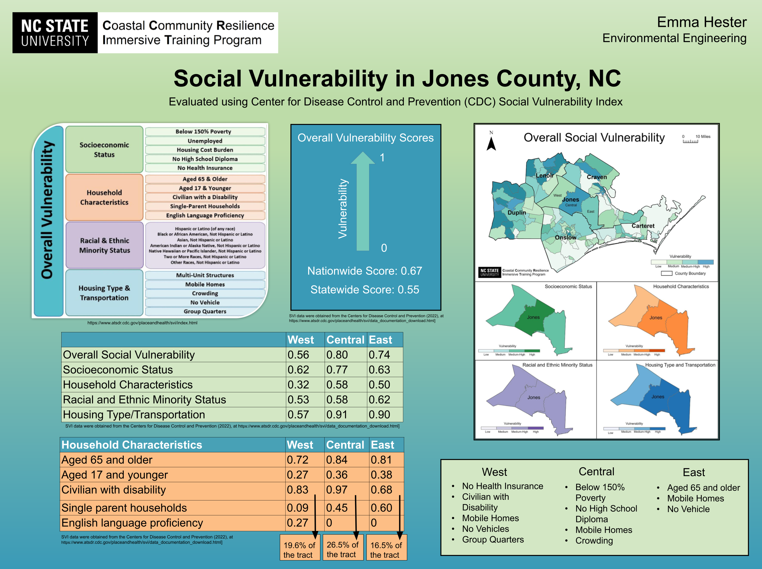
Social Vulnerability in Jones County, NC
Read more